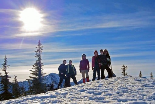
Zoa Peak Snowshoe
Your journey to Zoa Peak starts off highway 5 (Coquihalla Highway) exit 221-Falls Lake, which is 3 Km’s south of the tollbooth, north from Hope. Once leaving the highway, turn left and go under the highway and left again as if you are merging back onto the highway. This is where you will park, here is quite a bit of parking on the road. The road to Falls Lake parking lot is not plowed in the winter. There are no washrooms or pit toilets. This is a popular cross country skiing, down-hill skiing, snow boarding, ss’ing and snowmobiling area. Don’t forget your camera! Give yourself 5-6 hours return.
This was my second attempt at Zoa. My first attempt failed as there were no signs and trail markers were far and few. When I returned home that day I painted ‘Zoa Peak’ on 3 pieces of wood from the base of a Hemlock that fell down in our yard. I returned to Zoa a week later to mark the trails so others could enjoy this amazing snow shoe.
With Microspikes on my shoes and snow shoes on my back I travelled from the road about 1 km to the Falls Lake parking lot. It was good to have spikes & ss just in case there wasn’t enough snow. On this day in late January when it hadn’t snowed much, there was still plenty on the trail. After sinking into the soft powder off came my Microspikes and on went my snow shoes. I was glad I brought them as others wearing Microspikes were sinking to their thighs.

Zoa Peak is 11 Km’s return with an elevation gain of 635 metres. Keep in mind that if you travel by foot from the road to Falls Lake parking lot that adds about another km or so. If you go to Zoa’s sub peak it’s a little less than 11 Km’s return. Although some people do travel to Zoa’s true summit in the winter months we chose not to due to possible avalanche risk in the valley between the false and true peak/summit. I decided to save this journey for the summer, when it’s drier. Making it to the false summit/sub-peak offers stunning views of Nak & Yak Peaks, Jim Kelley Peak, Coquihalla Mountain, Falls Lake far below & Zoa Peak.

There is nothing gentle about this climb. It is up, up and up. There are many ways to Zoa but I will take you on the route I took. Starting from the Falls Lake parking lot, walking along the path over a partially frozen creek, past The Falls Lake sign on your left, shortly after there is a Cattle Guard sign. Steps past the sign there is a small trail to the left, a Zoa Peak hand painted wood sign rests in the trees along with flagging tape (do not keep walking on this lower road, this is not the way to Zoa Peak…you must turn left to get to the upper road). From this lower road, often named, Coldwater Road/Pipeline Maintenance Rd, go up a steep, tree covered trail to the Pipeline Road. Turn right and start walking up this wide road-like trail for about 800 metres/30 minutes. It is a steep, long haul but don’t give up…it’s worth every panting step. Don’t forget to look behind you as the views are spectacular. It is just before the crest in the ridge there was a cairn which seems to no longer be there. Turn left here, where another hand painted Zoa Peak wood sign hangs beside a little flagging tape. After a quick, steep scramble you are on the trail to Zoa Peak, surrounded by a quiet calming forest. There is new flagging tape and you can follow the ss path. Make your way up here for about an hour. Soon you will come to a flat section, meadows in the summer, now and a blanket of snow with stunning open views. A short walk and a few more little hills and you are at Zoa’s sub peak/false summit. Resting here on an old tired tree is the final wood hand painted Zoa false summit/Peak sign. Enjoy a snack and have a breather while your eyes take in breathtaking views in every direction. There are many ways down; some even do Zoa as a loop but best to go out the way you came in.


Happy & safe SS’ing trails!
Lori Pederson aka Scaredy Cat.
GPS Waypoints
Start from road by overpass: N49.612493, W121.065000
Start from Zoa Peak trail: N49.614449, W121.065649
Junction with Zoa Peak (Lori’s sign hung): N49.621137, W121.062668
Alternate Junction: N49.624719, W121.062369
False Summit Area: N49.625761, W121.082596
Lori Pederson is an Education Assistant for The Surrey School District. In her spare time she's an avid hiker, ss'er and loves Dragon Boating. She scouts out challenging but safe hikes & SS'ing and posts them to her hiking site, Hiking For The Scaredy Cat.
One response to “Zoa Peak Snowshoe”
Leave a Reply
Comments that gratuitously attack or demean individuals or organizations are not acceptable. We reserve the right to remove comments or any other content we deem unacceptable in our sole discretion, including removing user names and profile pictures. For our full website terms and conditions including our legal guidelines for user postings and comments on www.vancouvertrails.com, please see our Terms of Use and Privacy Policy.

What date was this?